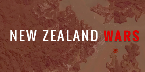
The language of our place names creates a striking snapshot of New Zealand's history.
The map below is coloured based on whether the place name contains Māori or English.
As you can see Māori names dominate the North Island outside of Auckland and Wellington,
while the South Island has predominantly English names.
Use double click, scroll, or a two fingered pinch to zoom the map. Drag the map to move
around.
The map was created by researchers from Te Pūnaha Matatini and Dragonfly Data Science supported by Te Hiku Media.
Kaitaia's Te Hiku Media is running a project that aims to teach computers to speak and understand Te Reo Māori.
They are developing tools to understand both written and spoken Te Reo.
The development of an acoustic model for Te Reo Māori is being crowd-sourced.
To build a reference of spoken Te Reo Te Hiku Media is asking Māori speakers use the website koreromaori.com record
themselves reading as little as ten sentences a day for a month.
While working on the written language portion of the project, Auckland University researchers, Max Bunting and William Ti'iti'i Asiata, developed computer programmes that identify Māori words in English texts. These tools where tested against the New Zealand Gazetteer of place names. The text recognition tools where then used to analyse the New Zealand Parliament's Hansard transcripts. The percentage of Te Reo spoken in Parliament has grown remarkably in the last ten years. Te Reo used to make up less that 0.1% of what was said in Parliament and now it is generally higher than 1%, and has been as high aa 2%.
The map below is coloured based on whether the place name are Māori
or English.