Extras You can't beat Wellington on a good day

This interactive map of Wellington City shows the best places to catch the sunshine at different times of the day.
This interactive map of Wellington City shows the best places to catch the sunshine at different times of the day.


Last updated: 20/11/2015

Recommended stories

Not only because of Wellington's notoriously bad weather reputation, we often found ourselves wondering how we can find the sunny areas for when the sun does come out.
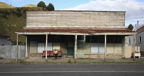
Even on a perfectly clear day, the capital's streets and public spaces are often shaded by the surrounding hills and high buildings. Particularly in winter, when the sun remains relatively low in the sky, knowing exactly when and where the sun will appear or disappear can be a very convenient piece of information. However this is much harder to calculate than the number of daylight hours between sunrise and sunset.
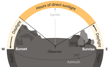
Where is the sunniest location? What is the latest spot to see the sun set? What time will the sun rise in my street? To answer questions like these, we developed an algorithm that allows rapid calculation of sunny and shaded areas that takes into account elevation data and the sun's relative position in the sky. Using publicly available data from the Wellington City Council, this method allows us to generate instant shade maps for the entire city at any given time.
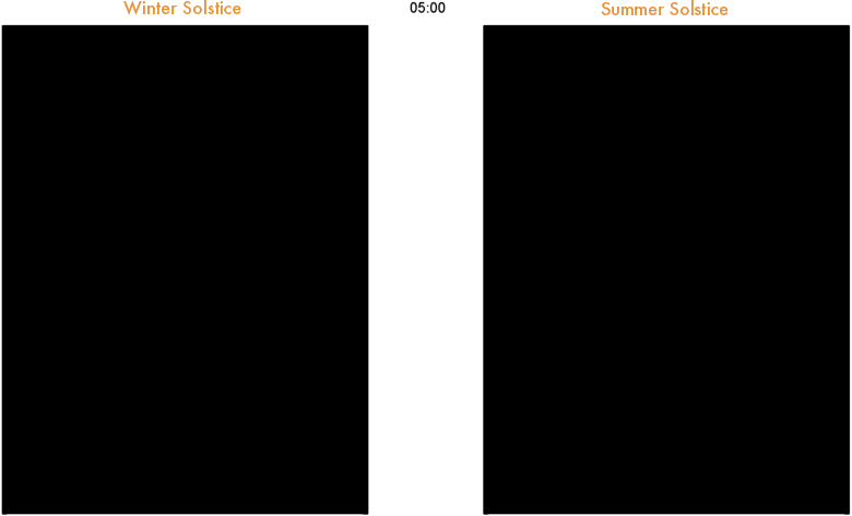
Having generated direct sunlight data for the whole year, we can now derive some interesting statistics like the average daily exposure or the averages for morning and afternoon hours. These are presented for Wellington in the following interactive map.
Whether looking at cities or regions with rugged landscapes, knowing precisely when the sun will appear or disappear and how much direct sunlight a location will receive may not only be relevant for our day to day life but also for a wide variety of domains such as:
Real estate to estimate the numbers of hours a property is exposed to direct sunlight; Transportation and road safety to identify road sections prone to ice hazards; Solar energy harvesting; Agriculture and gardening to determine the total amount of direct sunlight a land parcel will receive on a daily basis as a function of the season. Hospitality, for example when running an outdoor area Outdoor activities, such as skiing or hiking for example to determine how much sunlight a particular part of the trail may have received or when it is shaded ; Photography and film industry to look for optimal light conditions or ideal angles of the sun.
We would love to extend this study case to other cities in the near future and also increase the level of detail by using for example LiDAR data that would allow us to take vegetation into account. If anyone would like to contribute elevation data, please let us know.